|
Feb
28
2025
|
|
Posted 1 years 147 days ago ago by Admin
|
|

By Matt Johnson
Over the past several years, I have noticed applicants of all levels struggle with weather. And no, I am not talking about weather theory, which most enjoy as much as a root canal. I am referring to more of the application and correlation of weather products and how to interpret what you are observing, often in terms of color codes presented.
Often, applicants can recall (rote) what defines a ceiling and recite visibility and cloud clearance rules, but when asked, I commonly hear, "It all looks green – we should be good." And often, they miss minutia in the details.
One of the more prominent issues I have observed is not considering just how quickly a non-ceiling layer can become a ceiling.

As a reminder and going back to basics, cloud coverage levels are reported in eighths (oktas), with one okta of cloud cover being the equivalent of 1/8 of the sky covered at a given station equipped with necessary measuring instrumentation. Additionally, recall that a ceiling is defined as the lowest layer of broken (BKN) or overcast (OVC) clouds, whereas few(FEW) or scattered(SCT) is not technically considered a ceiling. Said another way in terms of measurement, a ceiling is the height of the lowest cloud layer that contributes at least five oktas (5/8) to the total sky cover, and this is where many pilots miss these small yet impactful details.
The typical heavy-hitter EFB apps are used as the source of weather information by most applicants, and please don't take me wrong; I fully support EFBs and these "heavy-hitter" apps. However, in many practical exams, applicants quickly glance at weather color-coding and make decisions without further analysis. Let's take another trip back to memory-lane-basics. The "Green-VFR" coding "Dots" are associated with conditions of: No ceiling or ceiling greater than 3,000 feet AGL and greater than 5-mile visibility, and the "Blue-MVFR" coding is for: a ceiling of 1,000 to 3,000 feet AGL and/or 3 to 5 miles, the "Red-IFR" coding follows with conditions represented by: a ceiling of 500 to below 1,000 feet AGL and/or 1 mile to less than 3 miles, and finally the "LIFR-Magenta" coding is associated with a ceiling below 500 feet AGL and/or less than 1 mile.
A few years ago, I facetiously uttered the phrase "green-dot syndrome" as a phrase used to describe situations where pilots accept a flight after a glance at the weather product displayed on their EFB, see "all green," and make the "go" decision without further exploration. Surprisingly, this phrase stuck, which isn't bad as it brings a new level of awareness to the problem. And here is the problem: the pilot (or applicant) purposes to depart only to find "lower than reported" ceilings even though everything is displaying green. The problem generally lies in the fact that the expressions FEW and SCT are not a ceiling; however, several factors should be considered: one, the amount of cloud coverage over a reporting station is just that, a limited sampling of that particular area; two, weather conditions often rapidly change and finally, because of the reporting classification measurements (oktas) what is reported as a SCT layer at 400 will show a "green dot" indication, yet that same 400 SCT layer is only one okta from being classified as a magenta dot or "LIFR."
For these very reasons, when making a weather decision, pilots must look at all associated layers of clouds that are being reported, ceiling or not!
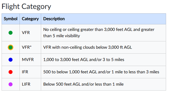
In 2023, I petitioned the National Weather Service to make a change on their new platform (www.aviationweather.gov) that would highlight FEW and SCT layers that could be impactful to pilot decision-making. They agreed to add another indication when FEW or SCT layers are reported as less than 3,000 feet. Now, when the conditions are reported as meteorological VFR (traditional green dot), yet FEW or SCT layers are also reported, you will now see an orange concentric ring around the green dot to bring your attention to those lower layers of clouds that aren't technically classified as a ceiling. Currently, the Aviation Weather Center of the NWS is the only entity providing pilots with this symbolic information. I encourage you to incorporate color-coded displays on the observation layer of www.aviatonweather.gov in your big-picture weather analysis to see areas with FEW and SCT layers that could impact you. Both in reality and on checkride day!
About the Author: Matt Johnson has been an FAA designated pilot examiner for over a decade, conducting exams ranging from Private to ATP and CFI. Additionally, he is a single-pilot IFR air medical captain and Part 135 instructor and check airman. He can be reached at [email protected] and via Twitter @HelicopterDPE
READ MORE ROTOR PRO: https://justhelicopters.com/Magazine
WATCH ROTOR PRO YOUTUBE CHANNEL: https://buff.ly/3Md0T3y
You can also find us on
Instagram - https://www.instagram.com/rotorpro1
Facebook - https://www.facebook.com/rotorpro1
Twitter - https://twitter.com/justhelicopters
LinkedIn - https://www.linkedin.com/company/rotorpro1