NTSB Preliminary Report: Ekalaka, MT
|
Location:
|
Ekalaka, MT
|
Accident Number:
|
WPR26FA031
|
|
Date & Time:
|
October 22, 2025, 18:30 Local
|
Registration:
|
N67GA
|
|
Aircraft:
|
ROBINSON HELICOPTER CO R66
|
Injuries:
|
4 Fatal
|
|
Flight Conducted Under:
|
Part 91: General aviation - Personal
|
|
|
On October 22, 2025, about 1830 mountain daylight time, a Robinson Helicopter Co. R66, N67GA, was substantially damaged when it was involved in an accident near Ekalaka, Montana. The pilot and 3 passengers were fatally injured. The helicopter was operated as a Title 14 Code of Federal Regulations Part 91 personal flight.
A friend of the accident pilot reported that about 1818, they departed from a private ranch located south of Ekalaka as a flight of two, which consisted of the accident helicopter and a Cessna 182. After takeoff, the friend queried the accident pilot if he was going to go direct to Ekalaka, and he replied that they were going to fly over the Chalk Buttes on the way to Ekalaka Airport (97M), Ekalaka. The friend offset his route of flight toward the Chalk Buttes and observed the helicopter off his left side and about 1/8th mile in trail at an altitude about the same height as the Chalk Buttes.
Just after entering the southwest end of the Chalk Buttes, the accident pilot transmitted that they were going to fly around the set of buttes off their left. The friend then observed the helicopter fly through a gap in the rocks and made a right turn towards the Cessna 182. The friend reported that the helicopter fell back in trail about 1/2 to 1 mile behind him, which was the last time he had visual contact with the helicopter. Approximately 1 minute later, the friend did not see the helicopter on ADS-B and despite multiple attempts, he was unable to establish radio contact with the accident pilot.
A witness, who was located about 3/4 mile southeast of the accident site reported that she was inside her residence when she heard the helicopter and airplane overflying her location and went to a nearby window to look. She stated that while looking to the north-northwest, she observed the helicopter flying low over the Buttes from left to right with the airplane in trail. She stated that the helicopter then began to gain altitude, and something came off it, after which it descended out of her line of sight.
This information is preliminary and subject to change.
Examination of the accident site revealed that the helicopter impacted an open field adjacent to a wooded area within the Chalk Buttes range at an elevation of 3,779 ft mean sea level. The helicopter came to rest on its left side, on a heading of 093°. The wreckage debris area was located southwest of the main wreckage and was about 300 ft wide by 300 ft long. The debris area contained fragments of Plexi glass, the left front and rear doors, tailrotor driveshaft cover, vertical and horizontal stabilizers, tailrotor, and the pilot side GPS mount. (See figure 1.)
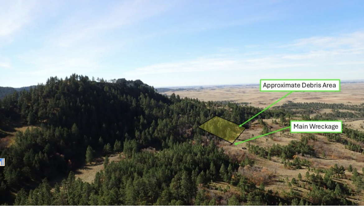
Figure 1: Accident site and approximate debris area. (Photo courtesy of Rolls Royce.)
The wreckage was recovered to a secure location for further examination.
Aircraft and Owner/Operator Information
|
Aircraft Make:
|
ROBINSON HELICOPTER
|
Registration:
|
N67GA
|
|
|
CO
|
|
|
|
Model/Series:
|
R66
|
Aircraft Category:
|
Helicopter
|
|
Amateur Built:
|
|
|
|
|
Operator:
|
On file
|
Operating Certificate(s)
|
Rotorcraft external load
|
|
|
|
Held:
|
(133), Agricultural aircraft
|
|
|
|
|
(137)
|
|
Operator Designator Code:
|
|
|
|
This information is preliminary and subject to change.
Meteorological Information and Flight Plan
|
Conditions at Accident Site:
|
VMC
|
Condition of Light:
|
Dusk
|
|
Observation Facility, Elevation:
|
KBHK,2962 ft msl
|
Observation Time:
|
18:51 Local
|
|
Distance from Accident Site:
|
39 Nautical Miles
|
Temperature/Dew Point:
|
6°C /-1°C
|
|
Lowest Cloud Condition:
|
Clear
|
Wind Speed/Gusts, Direction:
|
|
|
Lowest Ceiling:
|
None
|
Visibility:
|
10 miles
|
|
Altimeter Setting:
|
30.07 inches Hg
|
Type of Flight Plan Filed:
|
NONE
|
|
Departure Point:
|
Ekalaka, MT
|
Destination:
|
Ekalaka, MT
|
Wreckage and Impact Information
|
Crew Injuries:
|
1 Fatal
|
Aircraft Damage:
|
Substantial
|
|
Passenger Injuries:
|
3 Fatal
|
Aircraft Fire:
|
None
|
|
Ground Injuries:
|
|
Aircraft Explosion:
|
None
|
|
Total Injuries:
|
4 Fatal
|
Latitude, Longitude:
|
45.758719,-104.66093
|
Administrative Information
Investigator In Charge (IIC): Cawthra, Joshua
Additional Participating Persons: Tracy Brendal; Federal Aviation Administration; Helena, MT
Jon-Adam Michael; Rolls Royce; Indianapolis, IN
Thom Webster; Robinson Helicopter Company; Torrance, CA
Investigation Class: Class 3
This information is preliminary and subject to change.
READ MORE ROTOR PRO: https://justhelicopters.com/Magazine
WATCH ROTOR PRO YOUTUBE CHANNEL: https://buff.ly/3Md0T3y
You can also find us on
Instagram - https://www.instagram.com/rotorpro1
Facebook - https://www.facebook.com/rotorpro1
Twitter - https://twitter.com/justhelicopters
LinkedIn - https://www.linkedin.com/company/rotorpro1